Monday, October 03, 2005
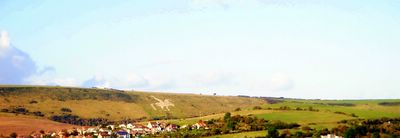
White Horse
This white horse figure is one of the many found over the hills in Dorset, England. This figure has been carved on chalk stone and is the only white horse figure in England with a rider.
Picture © 2005 onwards by Dr Himanshu Tyagi. All the photographs in this blog are copyright protected and can not be reproduced or stored in any medium without the written permission from Dr Himanshu Tyagi.
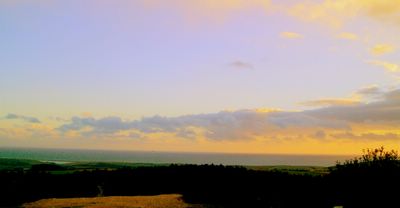
Dusk
Dusk or civil dusk is the time at which the sun is 6 degrees below the horizon in the evening. At this time objects are distinguishable but there is no longer enough light to perform any outdoor activities. Nautical dusk is the time at which the sun is 12 degrees below the horizon in the evening. At this time, objects are no longer distinguishable, and the horizon is no longer visible to the naked eye. Astronomical dusk is the time at which the sun is 18 degrees below the horizon in the evening. At this time the sun no longer illuminates the sky. Dusk should not be confused with sunset, which is the moment when the trailing edge of the Sun itself sinks below the horizon.
Picture © 2005 onwards by Dr Himanshu Tyagi. All the photographs in this blog are copyright protected and can not be reproduced or stored in any medium without the written permission from Dr Himanshu Tyagi.
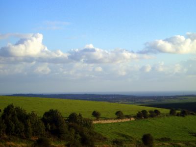
Portesham
Portesham is a village in the English county of Dorset, situated close to the south coast, between the towns of Weymouth and Dorchester. The village has a population of 708 (2001). The village of Abbotsbury is nearby, as is Hardy's Monument, erected in honour of Captain Thomas Hardy, one of Lord Nelson's commanders at the Battle of Trafalgar. Portesham is also in walking distance of the Jurassic Coast. This view is of the surronding area around Portesham.
Picture © 2005 onwards by Dr Himanshu Tyagi. All the photographs in this blog are copyright protected and can not be reproduced or stored in any medium without the written permission from Dr Himanshu Tyagi.
Hardy's Monument
Hardy's Monument is a 72foot high monument erected in memorial of Captain Thomas Hardy, a commander at the Battle of Trafalgar. The monument is situated on a high chalk hill overlooking the English Channel in the Blackdown area near Portesham in Dorset, England.
Picture © 2005 onwards by Dr Himanshu Tyagi. All the photographs in this blog are copyright protected and can not be reproduced or stored in any medium without the written permission from Dr Himanshu Tyagi.
Chesil Beach
Chesil Beach (sometimes called Chesil Bank) is a 18 mile (29km) long, 200 metre wide and 18 metre high shingle tombolo in Dorset, southern England. The beach is part of the Jurassic Coast World Heritage Site. This tombolo connects the Isle of Portland, a limestone island in the English channel to Abbotsbury, though it continues westwards to West Bay near Bridport, and it is the largest tombolo in England. The beach is steep showing a clear storm beach. Pebbles on the beach are graded, getting coarser nearer Portland, and fishermen familiar with the beach claim to be able to tell their location from pebble size alone. The pebbles are mainly flint and chert from the Cretaceous rocks which make up this stretch of the Heritage Coast. The origin of the beach has been argued over for some time, originally believed to be from the Budleigh Salterton pebble beds to the west and later from Portland to the south east. The differences between the pebbles on the beach and nearby sources is now put down to the Flandrian isotactic sea level rise so the feature could also be considered a barrier beach or bar that happens to connect the mainland to an island rather than a 'true' tombolo that is created due to the effects of the island on waves (through refraction) and so sediment transport. This usually produces a beach perpendicular to the mainland rather than parallel to it. The beach provides shelter from the prevailing winds and waves for the towns of Weymouth and Fortuneswell, which otherwise would probably not exist. At the Isle of Portland end of the beach, the beach curves round sharply to form Chesil Cove. This part of the beach protects the low lying village of Chiswell from flooding.
Picture © 2005 onwards by Dr Himanshu Tyagi. All the photographs in this blog are copyright protected and can not be reproduced or stored in any medium without the written permission from Dr Himanshu Tyagi.
Bowleaze Cove
Towards the east of Weymouth within the Weymouth Bay, there is a scenic cove called Bowleaze Cove. It can be walked to around the bay via Preston Beach. It is situated within the parish of Preston, which is known for historic Roman relics. The Cove is formed from the steep cliff on its eastern side. The beach is pebble and shingle leading to soft sand. It is popular for water sports. The River Jordan flows into the sea at Bowleaze Cove. It is a small river with its source in the hills above Sutton Poyntz.
Picture © 2005 onwards by Dr Himanshu Tyagi. All the photographs in this blog are copyright protected and can not be reproduced or stored in any medium without the written permission from Dr Himanshu Tyagi.
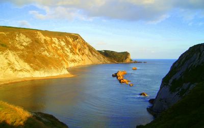
Man O' War Bay
Man O' War Bay as seen from the cliffs of Durdle Door in Dorset, England. The Purbeck Monoclines seen on the left adots a golden hue in the evening sun to give this beautiful bay a further magical touch.
Picture © 2005 onwards by Dr Himanshu Tyagi. All the photographs in this blog are copyright protected and can not be reproduced or stored in any medium without the written permission from Dr Himanshu Tyagi.
Jordan Hill Roman Temple
Jordan Hill Roman Temple in Overcombe, Weymouth, South of England. Despite being regarded as a temple, there is a faint possibility that it was an early lighthouse for guiding ships into the Bowleaze Cove. It was certainly not a military installation as there were no defences, and it was too large for purely domestic use.
Picture © 2005 onwards by Dr Himanshu Tyagi. All the photographs in this blog are copyright protected and can not be reproduced or stored in any medium without the written permission from Dr Himanshu Tyagi.
Overcombe
This stunning view of Weymouth Bay is from Jordan Hill in Overcombe. Overcombe is a town in south Dorset, England, situated on top of cliffs two miles east of Weymouth. It is also the location of Jordan Hill Roman Temple.
Picture © 2005 onwards by Dr Sanjukta Acharya. All the photographs in this blog are copyright protected and can not be reproduced or stored in any medium without the written permission from Dr Himanshu Tyagi.
Dungy Head
Dungy Head is the best place to see the Portland strata. The lowest part, the Portland Sand can be seen at the base of the cliffs, round the corner to the east of Dungy Head. It is an interesting place and some ammonites can be found. The Portland Stone (or Winspit Member) is mostly an oolite or ooid grainstone at Dungy Head becoming an ooid packstone east of Lulworth Cove (Townson, 1975). The Portland Cherty Series is well seen at Dungy Head and both the upper part or Dancing Ledge Member of Townson (1975) and the lower part, the Dungy Head Member, contains much sponge spicule (Rhaxella ) wackestone, the silica from which has given rise to the chert. Most of the chert is early, as is usually the case; some is late and related to faulting. The conspicuous thin marker bed know as Puffin Ledge (Puffins used to nest on in the Isle of Purbeck) is easily recognised as a thin bed in the middle and is usually characterised by Thallassinoides burrows. Giant ammonites, Titanites occur at about this level. Fine grained dolomites known as the Black Sandstones and part of the Gad Cliff Member. These contain the ammonite Glaucolithites.
References: 1. Dr Ian West, School of Ocean and Earth Sciences, Southampton University, Southampton Oceanography Centre, http://www.soton.ac.uk/~imw/dungy.htm
Picture © 2005 onwards by Dr Sanjukta Acharya. All the photographs in this blog are copyright protected and can not be reproduced or stored in any medium without the written permission from Dr Himanshu Tyagi.
Portland Limestone
Limestone is partially soluble, especially in acid, and therefore forms many erosion landforms. These include limestone pavements, pot holes, caves and gorges. Such erosion landscapes are known as karsts. Limestone is less resistant than most igneous rocks, but more resistant than most other sedimentary rocks. Limestone is therefore usually associated with hills and downland and occurs in regions with other sedimentary rocks, typically clays. Bands of limestone emerge from the Earth's surface in often spectacular rocky outcrops and islands. Examples include the Verdon Gorge in France; Malham Cove in North Yorkshire, England; and the Ha Long Bay National Park in Vietnam. This photograph was taken at West Lulworth Coast where Portland stone is still visible.
Picture © 2004 onwards by Dr Sanjukta Acharya. All the photographs in this blog are copyright protected and can not be reproduced or stored in any medium without the written permission from Dr Himanshu Tyagi.
Durdle Door
Durdle Door (sometimes spelt Durdle Dor) is a natural limestone arch on the Jurassic Coast near West Lulworth in Dorset, England. The arch has formed on a concordant coastline where bands of rock run parallel to the shoreline. Here the rock strata run near vertical, and the bands of rock are quite narrow. Originally a band of resistant Portland Limestone ran along the shore, the same band which can be seen two miles down the coast forming the narrow entrance to Lulworth Cove. Behind this is a 400 ft (120 metre) band of various weaker rocks which are easily eroded, and behind this is a stronger and much thicker band of chalk, which forms the Purbeck Hills. The limestone and chalk are much closer together here than at Swanage, ten miles to the east, where the distance between them is over two miles. This is because plate tectonics has twisted and folded the rocks forcing the strata vertical here, and this pressure has also compressed the clays. At Durdle bay all except a short stretch of the limestone has been completely eroded away by the sea and the remainder forms a small headland where it has protected the clay behind. At the western end this band of limestone has been eroded through, creating the natural arch. The 400 foot isthmus which joins the limestone to the chalk is made of a 50 metre band of Portland Limestone, which is less resistant than the Portland beds, a narrow and compressed band of Eocine clays, Wealdon Clay, sands and chert beds and then narrow bands of Greensand and sandstone. In Man-of-War bay, the small bay immediately east of Durdle Door the Portland stone has not been entirely eroded away, and at low tide the band of Portland stone is partially revealed. Durdle Door is a popular tourist "honeypot," as it is a short walk from the equally popular Lulworth Cove, and lies on the South West Coast Path. Within walking distance of the car park at Lulworth are these two unique landforms, a fossilised forrest and examples of common rock types from the Jurassic, Triassic and Cretaceous. The area is part of the 95 mile World Heritage Site because of its geology, and these factors make the site one of the most visited natural tourist attractions in the country, with the National Trust estimating the number of hiking journeys across Hambury Tout between Lulworth and Durdle Door as being over a million annually.
Picture © 2004 onwards by Dr Sanjukta Acharya. All the photographs in this blog are copyright protected and can not be reproduced or stored in any medium without the written permission from Dr Himanshu Tyagi.
Man O' War Rocks
The beautiful Man O' War Rocks in Man O' War Bay in Dorset, England. In this small bay immediately east of Durdle Door the Portland stone has not been entirely eroded away, and at low tide the band of Portland stone is partially revealed. This photograph was taken from the top of Purbeck Monocline.
© 2004 onwards by Dr Himanshu Tyagi. All the photographs in this blog are copyright protected and can not be reproduced or stored in any medium without the written permission from Dr Himanshu Tyagi.
Sunday, October 02, 2005
West Lulworth
West Lulworth is a village in the Purbeck district of Dorset, England, sitated on the English Channel coast beside Lulworth Cove. The village has a population of 766 (2001), 9.3% of dwellings are second homes. The village is a gateway town to the Jurassic Coast world heritage site and is a popular tourist "honeypot". This photograph was taken from the Purbeck Hills south west of West Lulworth and shows the picteresque landscape of the surroundings of this small village.
© 2004 onwards by Dr Himanshu Tyagi. All the photographs in this blog are copyright protected and can not be reproduced or stored in any medium without the written permission from Dr Himanshu Tyagi.
Subscribe to:
Posts (Atom)